- Location
- British Columbia and Alberta
- Offices
-
-
Client
-
-
Geological Survey of Canada,
-
Natural Resources Canada
-
- Location
- British Columbia and Alberta
- Offices
- Client
-
- Geological Survey of Canada,
- Natural Resources Canada
Share
Assessing Landslides with DebrisFlow Predictor
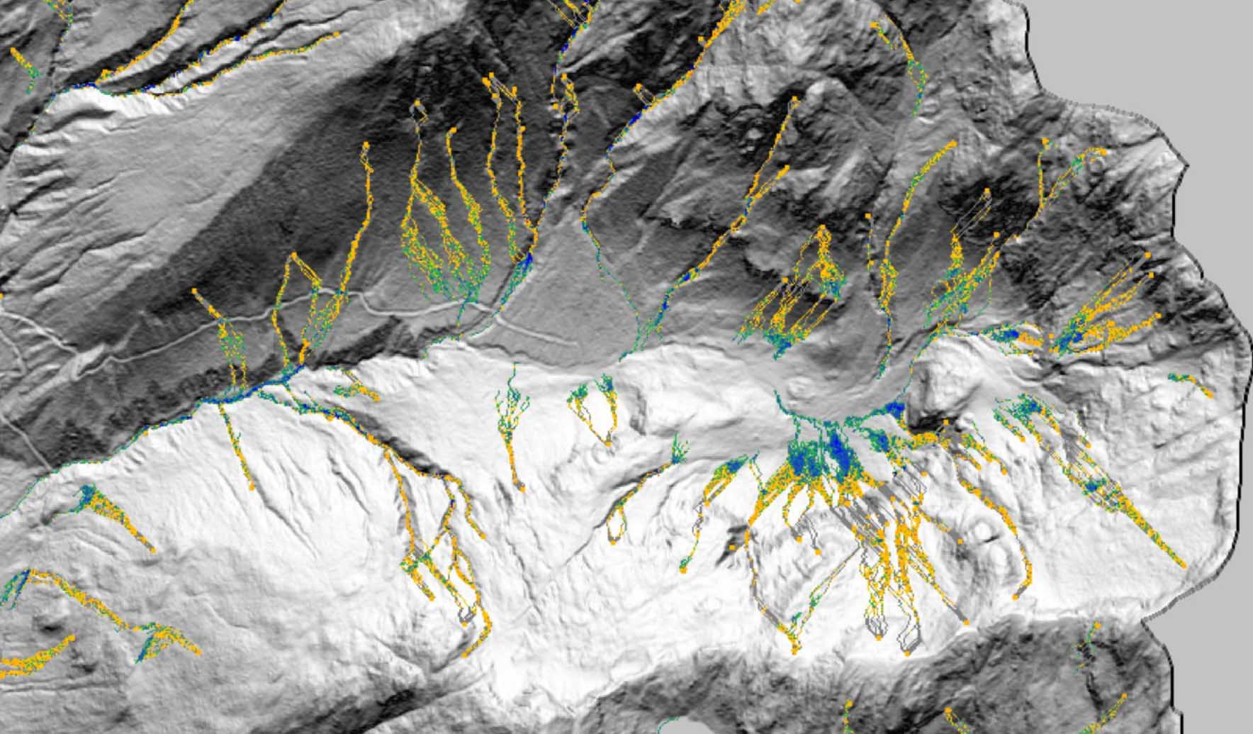
The mountainous terrain of British Columbia and Alberta is highly prone to landslides. This presents a challenge to the Geological Survey of Canada (GSC), which has a mandate to protect the public from such hazards. Landslide simulation software has the potential to inform communities and increase resilience from these hazards.
GSC set out to assess the applicability and use cases of DebrisFlow Predictor, our landslide runout model, across the diverse mountainous terrain in these provinces. They partnered with us under a grant from Innovative Solutions Canada, an initiative designed to stimulate technology research and development of Canadian innovations.
We modeled 800 square kilometers (497 square miles) of steep, mountainous terrain across four study areas. The simulation results proved credible at all scales and conformed with real-world examples in each study area. In Waterton National Park, for example, debris flows that occurred after modeling were consistent with our simulation results for debris flow locations, depth, and extent.
One innovative technique we used in this study was developing a “landslide hazard fingerprint,” a signature of such hazards unique to each area that can be used to quantify the probability of encountering landslides in the receiving zone, regardless of source. This fingerprint helps land managers focus planning efforts on receptors—such as houses, waterbodies, transportation corridors, and power and energy infrastructure—that are most likely to interact with the hazard.
With DebrisFlow Predictor calibrated to a variety of physiographic regions and climate zones, GSC and others can use this model with confidence to address the real-world problem of landslide runout and inundation. GSC also intends to release several open file reports to describe the results of this modeling to the scientific community.
- Location
- British Columbia and Alberta
- Offices
-
-
Client
-
-
Geological Survey of Canada,
-
Natural Resources Canada
-
- Location
- British Columbia and Alberta
- Offices
- Client
-
- Geological Survey of Canada,
- Natural Resources Canada
Share
Richard Guthrie, Vice President
Geohazard innovation is about designing new, novel, and safe solutions that benefit clients, project teams, and our field of work.
Thad Wasklewicz, Principal, Geohazards and Geomorphology
Collaborating regularly with our communities provides a clear understanding of how we can proactively prepare for future geohazards.
Graham Knibbs, Geoscientist
With a knack for problem solving, I believe in finding effective solutions and creating opportunities for innovation.
Emma Reid, Principal Engineering Geomorphologist
I help clients understand and visualize hazards so they can make the best decisions to protect their infrastructure and communities.


We’re better together
-
Become a client
Partner with us today to change how tomorrow looks. You’re exactly what’s needed to help us make it happen in your community.
-
Design your career
Work with passionate people who are experts in their field. Our teams love what they do and are driven by how their work makes an impact on the communities they serve.